
Start With a Westborough Street Address
Use the full house number and the current street spelling before trying a name. The municipal assessor search separates street number from street name, so each can be entered on its own. That is especially helpful when a suffix varies between records. Patriot Properties is the Town of Westborough's free FY2026 property database. It can return a parcel, location, owner, building type, value, sale reference, and book/page without treating any of those entries as proof that a particular person lives there.
- Enter the number and street name in the assessor search. Save the parcel ID, situs address, owner or mailing field, and book/page reference if a result is returned.
- Open the town GIS, use its left search box, select the Westborough address result, choose Assessors Parcel Data, and click the highlighted parcel. The popup provides the parcel context and zoning.
- Use the parcel and book/page as the bridge to the Worcester Registry of Deeds. Read an actual instrument before drawing a conclusion about ownership or a transfer.
- For a year-specific address question, consult the Westborough Street Lists or other dated local material. A historical listing is a dated publication, not a current household roster.
The sequence is address to parcel, parcel to legal reference, then dated local evidence. It avoids joining people merely because they share a surname or a street.
Westborough Street Directory Record Trail
Several Westborough sources are keyed to an address, but they do not carry the same meaning. The table separates a current property description from a recorded deed, a building-record trail, and the older materials used to place an address in time.
| Address source | Westborough clue | Best use | Important limit |
|---|---|---|---|
| Patriot Properties | Parcel ID, situs, owner or mailing field, building facts, book/page | Begin a current parcel search | Owner and mailing fields do not prove occupancy |
| Town GIS and MassGIS | Parcel shape, zoning, nearby parcels and map context | Place an address on the ground | Map results are not a survey or title opinion |
| Worcester Registry | Grantor, grantee, document, recording date and legal reference | Trace recorded land instruments | Name indexing is uneven before modern computer records |
| Laserfiche and PermitPro | Address or parcel-linked municipal building material | Check documented property activity | PermitPro's current/active coverage has a stated cutoff |
| Street Lists and local collections | House numbers, names, same-house marker and occasional occupation | Answer a dated address question | Coverage and protected fields vary by year |
Street names connect these sources, but the parcel number is usually the stronger cross-check. A book/page on the assessor card can lead directly to a Registry book search. A result in an old street list belongs to its edition year, even if the house number still exists.
Westborough Street Search Fields
The assessor's optional filters make it possible to narrow a street without treating the search as a people list. Start with street number and street name. Parcel and book/page are stronger keys when they are already known. Value, lot size, year built, finished area, sale date, beds, baths, neighborhood code, and land-use code can narrow a broad result, but they are property descriptors rather than identity evidence.
| Field | How it works for an address search |
|---|---|
| Street number and street name | Separate optional fields; test a suffix variant if an exact search misses. |
| Parcel | Use the exact parcel or account key once a card has been identified. |
| Owner | Optional text that can help locate an entity or spelling variant, not an occupancy finding. |
| Book and page | Two optional fields that link the parcel card to recorded land research. |
| Sale price and date | Useful for locating a transfer; a nominal price calls for reading the deed. |
| LUC and building type | Property-use classifications, not household categories. |
Results can be sorted by their headings, and a Parcel ID opens the detail card. The portal also offers a print-page control. It is sensible to record the search date because FY2026 assessment data and result details can change with later municipal updates.
Westborough Address Terms That Matter
Small label differences can prevent a bad match. The assessor card uses its own fields, while deed research adds a legal reference. These terms keep the Westborough street directory process focused on what each record actually says.
- Parcel ID
- A local identifier for a mapped property. It is often the most stable bridge between a card and a map.
- Situs address
- The physical property location. It can differ from the owner's mailing address.
- Book/page
- The Registry reference used to locate a recorded instrument in a specific book and page.
- Grantor and grantee
- The parties recorded as transferring an interest. They identify a document role, not automatically a current resident.
- Street list
- A dated municipal or local listing organized around streets and house numbers, not a permanent household record.
Read the label before copying a field into notes. Keeping a situs, mailing address, parcel ID, and book/page separate makes it easier to revisit the source without implying more than it reports.
Westborough Street Parcels and Zoning
The town's GIS route begins with the left search box, followed by the Westborough address result and Assessors Parcel Data. Clicking the highlighted parcel opens the popup with zoning. This is a practical way to check whether two addresses are separate parcels, to see the street context, or to identify a nearby parcel that should be reviewed separately.
MassGIS documents complementary controls such as address type-ahead, parcel clicks, an attribute table, selected or map-extent filters, and Find Abutters. The town's static parcel-map index covers numbered maps and warns that its maps are not legal documents or for assessment or reference purposes. Treat an adjacent shape as spatial context. It does not establish a boundary line, legal title, or a list of people at that address.
Useful map check. Compare the parcel's zoning with the town's current zoning map before describing the setting. Codes such as R, C, BB, IA, IB, IC, M-1, and MUD describe land-use context, not the people associated with a street.
Westborough Book Pages Lead to Deeds
Worcester District Registry of Deeds records are described as reaching from 1731 to today. Begin with the exact book/page on the assessor card when it is available. In MassLandRecords, the Book Search can surface the instrument tied to that reference. Record the document type, recording date, grantor, grantee, consideration, legal description, and any prior reference before tracing another link.
A deed chain moves backward through prior grantors and forward through later grantees. Mortgages, releases, liens, trustee roles, estates, and legal descriptions can change the interpretation. The Registry's public search, viewing, printing, and downloading were available when researched, though browser controls can change. Recorded instruments document transactions and title-related filings; they are not a complete resident list.
Westborough Pre-1960 Deed Names
Older address work needs more than a normal name search. The Registry interface offers separate Pre-1960 Grantor Index and Pre-1960 Grantee Index modes alongside Name, Document, Book, Property, Recorded Date, and Unindexed Property searches. Records and images can reach back to 1731, but regular computer-name coverage is not uniform before the modern era. A Worcester library guide reports computer indexing from 1966 forward, so a missing modern-style result is not a final answer for an earlier deed.
Search both party directions and try both Westborough and Westboro. That spelling variation also belongs in older directories, maps, and legal descriptions. The exact year boundary for every indexing mode was not resolved in the reviewed official material, which is a reason to inspect the page image or microfilm when an older reference matters.
Westborough Building Records by Address
Historical municipal building documents are available through the town's Laserfiche repository. Town instructions advise searching by address or parcel ID, omitting the street suffix, and ending the street name with an asterisk. For example, the town's pattern is a number followed by a partial street name and *. That broadens a search enough to catch documents whose suffix or address formatting differs.
Use an address and parcel together when possible. Building documents can show that a municipal record exists for a property, but they do not settle title, establish a current household, or fill gaps in historical coverage. Keep the document date and the office source with any notes.
Westborough PermitPro Street Records
The town identifies PermitPro as the route for current and active permits from September 2018 to the present. Its public instructions say to open the public-information option, type an address, choose the autocomplete result, select the gear, choose Documents, then use the down arrow. The visible instructions do not establish a full historical field inventory or an earlier cutoff, so it is best used as a documented current-era permit lead.
See the Westborough PermitPro public portal for the address-entry interface used in this part of the street directory search.
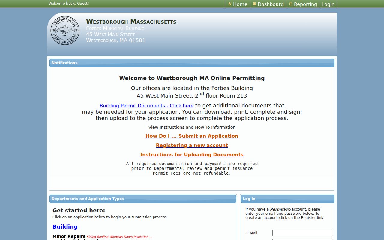
The portal view reinforces why the address should be entered exactly before a document trail is considered. It supports property research, not conclusions about who occupies a location.
Westborough Street Lists Since 1924
For earlier households, the Westborough Archive's house-research guidance points to Street Lists from 1924 to the present. The black bound books are described as usually showing names, house numbers, a same-house-last-year marker, occupation, and sometimes nationality. Town Reports can help with missing years. These are unusually strong local address leads because they are organized around the house number rather than a general web search.
Historical city directories, maps, deeds, newspapers, and the Street Lists should be compared rather than collapsed into one conclusion. A house number may have been renumbered, a corner lot may use another description, and old records may say Westboro. The research did not locate an authoritative townwide renumbering table or a complete legal spelling-change chronology. A specific continuity claim needs the actual map, list, deed, or town action behind it.
Westborough Street Directory Limits
An address-based record can identify a parcel, a recorded party, or a dated publication entry. It cannot safely be converted into a current list of every person on a street. Assessor owner and mailing fields are not occupancy proof. A deed party may be an entity, trustee, or past owner. Public voter material is subject to statutory exclusions, and protected addresses, confidential voter records, phone numbers, email, veteran status, permanent absentee status, and minors' information must not be republished.
Massachusetts's Address Confidentiality Program protects survivors who have relocated, and no apparent online address should be used to defeat that protection. Driver and vehicle information is restricted under federal law. The sound practice is to preserve only the minimum address, parcel, date, and source details needed for personal, lawful research, then verify important facts with the office that keeps the record.
Lawful use. Westborough address records are for personal, lawful research, family history, civic curiosity, and property questions. Do not use them to stalk, harass, intimidate, or harm anyone, and do not publish sensitive information about private people.